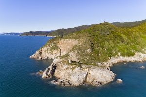
Te Matau / Separation Point is the point that marks the separation between Tasman and Golden Bays. Explorer Dumont D’Urville named it the very practical Separation Point, while the Māori name is more evocative.

It is therefore understandable that a landform similar to a hook, located on Māui’s waka, could be called Te Matau. This is Separation Point. It marks the part of the hook that catches on the fish’s jaw, the complete hook being represented in the shape of Golden Bay/Mohua and Onetahua/Farewell Spit.
Hence Te Matau is a distinctive part of the local coastal landscape. But it was also a boundary. Several iwi extend their territory to Te Matau, and it was around Te Matau that waka had to come on a journey east or west.
Te Matau is the most ‘Cook Strait-like’ (dry, mild, windy) of any place in the Abel Tasman National Park and several species of plants native to the park are found only there. As well, the ‘hook’ extends deep into the sea, and on this turbulent ridge, colonies of large bryozoans (also known as moss animals and sea mats) create a unique nursery for fish around the park coast.


